




In October 2026 Pietro Miotti published a first-person account of using multimodal AI agents and public lidar to flag a Maya hilltop with plaza, pyramid, and courtyard shapes under jungle canopy—and receiving an INAH reply that no registered archaeological site sat at the coordinates he reported. The story spread on Hacker News as a rare non-coding agent win: science workflow in under 72 hours.
It is not a confirmed archaeological discovery. It is a concrete template for how general agents, public Earth observation data, and government inboxes interact when a motivated outsider runs an experiment responsibly.
TL;DR
| Step | What happened (per Miotti's diary) |
|---|---|
| Oct 18 | Idea after reading about Hiram Bingham; agents suggest lidar over Maya region |
| Oct 19 | ~1,200 km² lidar rendered; 48 agent passes flag geometric sites |
| Oct 19–20 | Agents check literature; one hilltop not found in cited archives |
| Oct 20 | Report translated to Spanish; sent to INAH with confidential coordinate annex |
| Oct 21 | INAH email: no registered site at reported location |
| Status | Not official discovery; field verification needs INAH-led work |
Why lidar—and why agents?
From orbit, a jungle ruin is just trees. Miotti's post explains that lidar pulses through canopy gaps and maps bare-earth elevation, revealing straight edges and platforms satellites miss.
He explicitly says there was no special classifier: agents looked at pictures following a guide, like patient human surveyors at scale. That is closer to remote labor benchmarks than to a bespoke foundation model—orchestration + vision over strips already collected for environmental research (he cites NASA G-LiHT and reuse papers).
The hilltop he highlights shows a levelled plaza, an 8–12 m pyramid mass, a raised courtyard, and a flat-bottomed hollow that might have stored water—classic Maya civic-centre morphology in his interpretation.
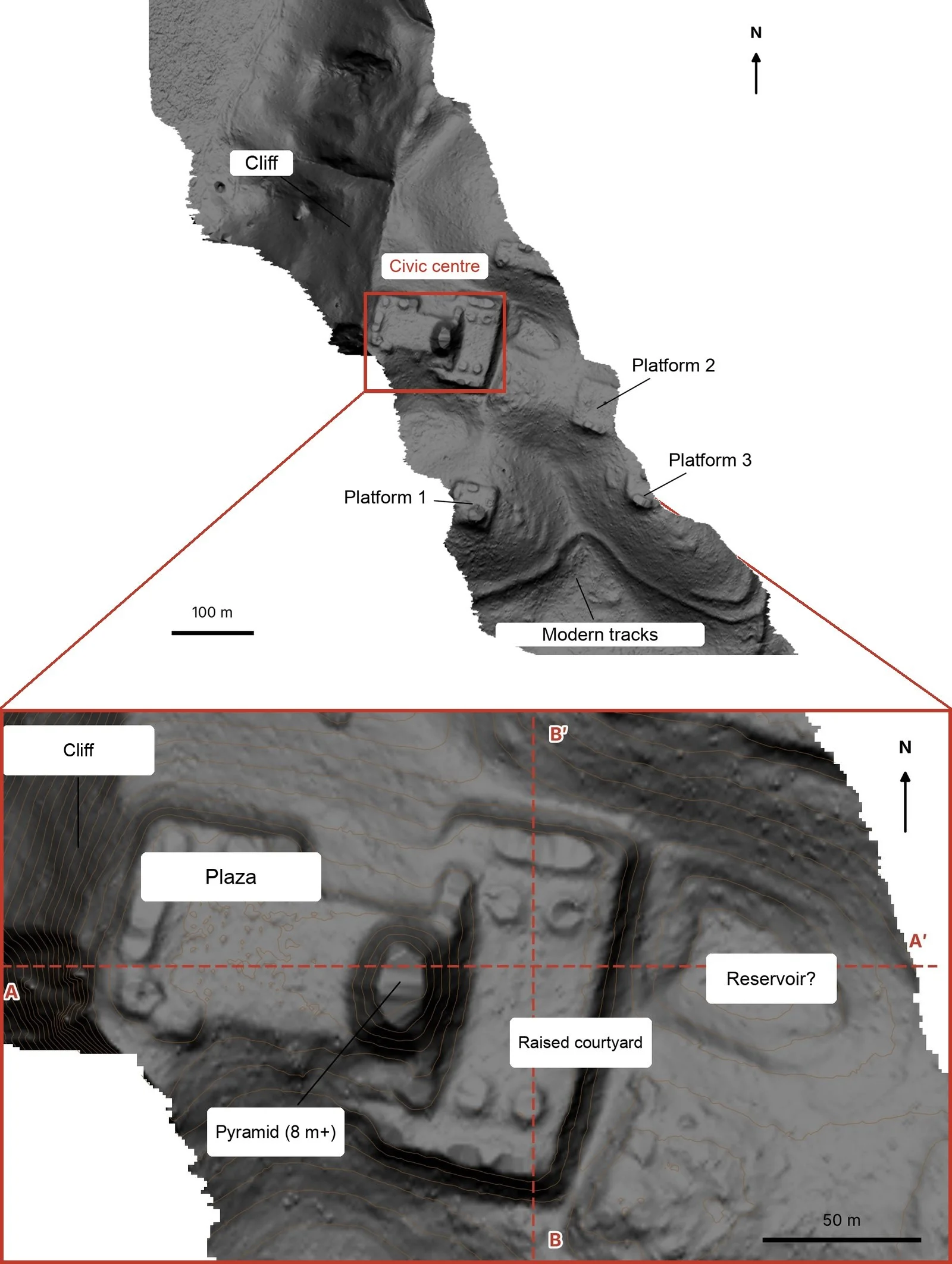 AI agents flagged Maya civic centre structures in bare-earth lidar under jungle canopy
Image: Pietro Miotti
The agent stack Miotti actually used
Miotti names Gemini, ChatGPT, Claude, and Grok across the diary—not one vendor bet. Tasks split naturally:
- Brainstorming data sources and regional coverage
- Overnight batch review of rendered lidar tiles
- Literature and archive search for prior registrations
- INAH process instructions and email addresses
- Report drafting and Spanish translation
- Point-cloud sanity checks separating canopy returns from ground
- Artistic reconstruction visualization (explicitly labeled generated)
That mirrors how practitioners already mix models in useful Claude Code agent projects and agent skills workflows: specialists per subtask, human review between irreversible steps.
What was not automated
Miotti sent coordinates in a confidential annex, iterated the report when agents got details wrong, and offered field help only under INAH authority—required under Mexican federal heritage law he acknowledges. Agents did not loot, dig, or publish precise GPS in the public post.
INAH's reply—and what it does and does not mean
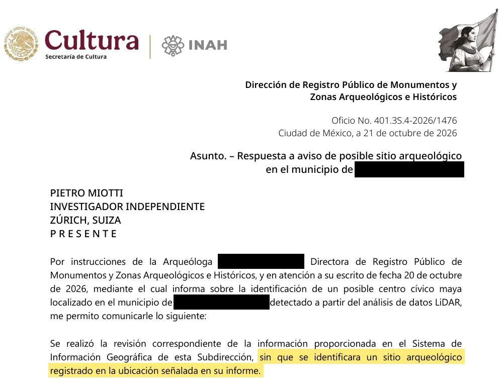 INAH reply that no registered archaeological site existed at the AI-reported coordinates
Image: Pietro Miotti
Miotti screenshots INAH's October 21 answer: no registered archaeological site at the location in his report. That is administrative novelty, not a peer-reviewed paper.
Possibilities archaeologists routinely consider:
- A genuine unmapped civic centre awaiting ground truthing
- A known feature present in lidar catalogs Miotti's agents did not query completely
- A natural geomorphology misread as platforms (less likely when multiple aligned structures appear)
The blog is transparent that interpretation after INAH's note remains speculation—Classic-period civic centre, elite compound, possible aguada reservoir.
What developers are saying on Hacker News
The HN thread is thin but substantive. User ks2048 (comment) argues large lidar campaigns already catalog nearly 100,000 structures and shares public polygon viewers, asking whether Miotti or the agents searched those indexes first.
That is the right skepticism for builders: agent speed is useless if your retrieval step misses the national catalog. A production pipeline would mandate GIS cross-checks against INAH and academic shapefiles before email, not only LLM literature search.
How this differs from lab archaeology ML
Recent Maya lidar science includes peer-reviewed city-scale finds and population estimates Miotti cites at the bottom of his post. Those papers used domain teams, years of validation, and **institutional partnerships.
Miotti's experiment is closer to citizen acceleration: a naive outsider plus compute plus polite reporting. The lesson for AI teams is breadth: agents are not only for IDEs and Kubernetes YAML—they chain search, vision, translation, and bureaucratic formatting on public datasets anyone can download.
Compare to Google and Janelia's fruit-fly connectome work: institutional science still wins on proof, but individuals can now initiate credible tickets in days.
Replicating the pattern (without heritage harm)
If you adapt this workflow for other geospatial science:
- Start from licensed or public lidar or satellite products with clear citation.
- Log every agent pass and keep humans on send/no-send for government mail.
- Cross-check discoveries against authoritative registries before claiming novelty.
- Withhold precise coordinates publicly when law or stewardship requires it.
- Treat model reconstructions as illustrations, not evidence.
For general agent security when tools browse untrusted pages, pair human review with practices from Claude Code prompt-injection reminders and our agent skills production pack guidance.
What people are asking
| Question | Practical answer |
|---|---|
| Can I discover ruins with ChatGPT alone? | You still need geospatial data, QC, and institutional reporting—models coordinate text, not lasers. |
| Is Miotti an archaeologist? | He states he is not; treat structure IDs as hypotheses. |
| Did INAH confirm a new site? | They said none registered at the point—field science may still follow. |
| Was a custom model trained? | No, per his account—vision over renders with agent labor. |
Prior science Miotti cites—and why context matters
Miotti's footer links peer-reviewed lidar archaeology threads readers should not skip:
- Cook et al. 2013 on NASA G-LiHT instrumentation—the hardware lineage behind many airborne strips.
- Golden et al. 2016 on reusing environmental lidar for archaeology.
- Auld-Thomas et al. 2024 on a Maya city found via lidar surveys at institutional scale.
- Estrada-Belli et al. 2025 on population estimates from lowland lidar.
- Šprajc 2026 on possible ancient marketplaces detected in lidar.
Those papers establish that machines finding rectangles under trees is not new. Miotti's twist is agent labor at hobbyist speed: one person coordinating 48 parallel visual reviews, literature checks, and bilingual bureaucracy without a grant consortium.
If you work in computer vision, treat this as human-in-the-loop at scale, not a replacement for INAH archaeologists who hold excavation authority.
 Computer vision style review of geospatial lidar strips for structure detection
Compute, cost, and honesty about "48 agents"
Miotti writes that 48 agents reviewed lidar tiles overnight like patient archaeologists. In practice that means dozens of parallel vision-heavy model calls over rendered strips—not a single cheap embedding search. Budget planners should expect:
- Egress and storage for lidar tiles if you mirror strips locally instead of streaming from agency portals.
- Vision token charges if you use frontier multimodal APIs on thousands of PNGs.
- Human QC hours the next morning—Miotti's diary shows he iterated the report when agents erred.
The story is still cheaper than chartering airborne lidar, but it is not free compute. Teams chasing remote labor automation metrics should log dollars per square kilometer screened when pitching science leads, not only romance about Bingham.
When agents disagreed, Miotti kept multiple model families in the loop rather than trusting a single vendor verdict—a pattern that also shows up in enterprise eval harnesses discussed around Bedrock AgentCore playbooks.
A minimal replication recipe for other regions
Adapt Miotti's pattern only where law and licenses allow:
| Stage | Tooling | Human gate |
|---|---|---|
| Source data | Public lidar or satellite composites with citation | Verify license for commercial reuse |
| Tiling | Render bare-earth RGB or hillshade tiles | Spot-check one tile manually |
| Screening | Agent batches with a written rubric (plaza, platform, road) | Discard obvious geology |
| Registry cross-check | Query national heritage GIS + academic shapefiles | Mandatory before publicity |
| Reporting | Draft PDF in local language | Lawyer or local partner reviews send |
| Publication | Blog without precise lootable coordinates | Wait for agency response |
Pair registry checks with the skepticism surfaced on Hacker News—ks2048's point about existing polygon maps is a free test your pipeline should automate on day one.
Ethics and hype guardrails
- Do not treat INAH's email as a Nature paper.
- Do not publish lootable coordinates to drive engagement.
- Credit public lidar programs and prior Maya lidar science Miotti links.
- Avoid claiming agents replace archaeologists—they compress paperwork and search, not trowels.
Related reading on explainx.ai
- Build useful agents with Claude Code
- What are agent skills?
- Remote labor index and automation rates
- Addy Osmani on agent skills in production
- Google fruit-fly connectome and AI reconstruction
- Claude Code prompt-injection concealment risks
Timeline and images follow Pietro Miotti's post as published; INAH's reply is shown there in Spanish. Field confirmation, if any, will come from Mexican authorities—not from a blog rollout.